2021 Winter Virtual Series #4 – Green River College
Saturday, February 20 thru Friday, March 12 at Green River College in Auburn, WA
We’re starting a new decade with a new (but hopefully short-lived) series: the Winter Virtual Series.
See the Winter Virtual Series page for more information and registration details.
Please NOTE: Even though these are not organized events, please follow the WA state guidelines and wear a mask whenever you are approaching or passing other people or are within 6 feet of others.
COURSES
Course designer(s): Dave Tallent
The courses are short so you can run more than one, run the same course multiple times, and/or try out different route choices.
White (Beginner) – 0.7k, 6 controls
Yellow (Advanced Beginner) – 1.7k, 8 controls
Orange (Intermediate) – 1.8k, 10 controls
Red (Advanced) – 2.9k, 17 controls
The maps in the app are designed to print on letter-size paper and include only the area around the course. If you’d like a copy of the entire map (11 x 17 inches), click below.
White (11 x 17)
Yellow (11 x 17)
Orange (11 x 17)
Red (11 x 17)
How are courses measured?
Courses are measured as the crow flies, in a direct line from control to control. Unless you have wings, you will travel farther than this distance! Courses are measured in kilometers, so a good rule of thumb is to simply round up to miles to estimate how far you will go. So in a 5 kilometer race, you’ll likely travel up to 5 miles.
SCHEDULE
- February 19, 6pm – Courses posted to UsynligO
- March 12, 6pm – Courses closed for scoring
PRICES
There is no fee for the virtual events.
SIGN UP
See the Winter Virtual Series page for details.
LOCATION
PARKING
Parking is available at Green River College.
RESTROOMS
We can’t guarantee that restrooms will be available. Please plan accordingly.
THE MAP
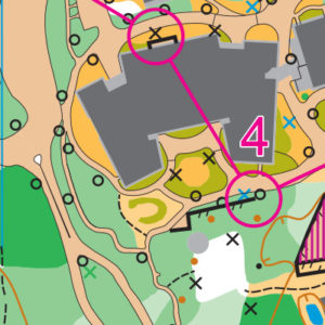
Green River College is almost like two venues–a dense college campus surrounded by thick forest and undergrowth with infrequent trails, some of which are prone to winter flooding. Over time, Cascade Orienteering Club has focused more on the campus, expanding that portion into a 1:4000 sprint map.
As with any campus map, good awareness of building shapes, size, and direction–and the fact that you’re on a 1:4000 map–help with navigation. Note that the underground garage in the large, northeastern-most building is out of bounds and cannot be used for navigation. Other out-of-bounds areas are fenced. And as always, look both ways when crossing a road; there are lots of parking lots here!
Read more on the map pageSAFETY & ETIQUETTE
Return to the Finish
All participants MUST return to the finish and download their e-punch or turn in their punch card.
Even if you have not finished your course, you must still return to the the finish and confirm with event staff that you have returned safely.
Out of Bounds
Some areas may be marked out of bounds. It is imperative to respect these boundaries to maintain our relationships with land managers. Participants MUST NOT go out of bounds. Any participant caught going out of bounds will be disqualified.
Course Closure
All participants MUST return to the finish by course closure time. If a participant does not return by course closure, event volunteers will begin coordinating a search party.
If you need a long time on the course, start as early in the start window as possible, wear a watch, and be prepared to cut your course short to make it back by the course closure time.
Whistle
All participants MUST carry a whistle on the course. Complimentary whistles are available at the start tent (please only take one).
If you are injured on the course and need assistance, blow three long blasts to call for help.
If you hear a call for help, abandon your course to find the person in distress.
Voices
Part of the fun and fairness of orienteering is navigating your own course, so please be polite when you find a checkpoint and don’t holler that you’ve found it.


