2022-23 Winter League Championships – Fire Mountain Scout Camp
WINTER LEAGUE
Saturday, February 18 at Fire Mountain Scout Camp in Mount Vernon, WA
- ALL runners will be called to enter the start procedure line 10 minutes prior to their assigned/picked start time. Please Be Race Ready when your name is called.
- Pre-registration is required. There is no day-of-event registration.
- Course closure is 2:15 pm for this meet.
- List of assigned Start Times is Here.
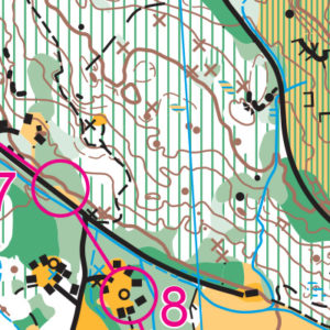
- Site Map is here.
- PUBLIC Start Time Sign-Ups Here. The signup is now closed.
- 2022-23 WIOL Rules Here.
- See New Start Procedures Here.
Winter League is the Pacific Northwest’s premier competitive orienteering series for all ages.
- Elementary, Middle School, High School and College students compete under the banner of the Washington Interscholastic Orienteering League (WIOL).
- Winter League public courses offer a range of categories from a competitive long advanced category to non-competitive beginner-friendly categories at every event!
COURSES
Course designer(s): Mike Schuh
Course Data
| Course | Controls | Distance | Climb |
| White / Elementary / Beginner | 8 | 2.1 km | 20 m |
| Yellow X /Middle School | 9 | 2.1 km | 35 m |
| Yellow Y /JV Rookie / Advanced Beginner | 9 | 2.0 km | 35 m |
| Orange X /JV Male | 12 | 2.5 km | 50 m |
| Orange Y /JV Female /Intermediate | 12 | 2.5 km | 55 m |
| Brown / Varsity Female /Advanced Shorter | 11 | 3.1 km | 55 m |
| Green /Varsity Male/ Short Advanced | 15 | 3.1 km | 70 m |
| Red / Collegiate Female /Long Advanced Female | 17 | 3.8 km | 95 m |
| Blue /Collegiate Male / Long Advanced Male | 19 | 5.4 km | 155 m |
Which course should I sign up for?
This Meet is a National Ranking Event (NRE) and also Winter League Championships.
- If you do not care about NRE points or NRE awards, sign up for the course of your choice.
- If you want to be eligible to win a WL Championship award, sign up for either short advanced or long advanced.
- If you want NRE points:
You must sign up for a course that has a qualifying age category for you. Your “orienteering age” is based on your year of birth, not your actual birthdate. For example, if you were born in the year 1987, your orienteering age is 35 for this entire year.
We will need everyone’s birthdate even if you don’t want ranking points. We’ll use the date you have in your registration account, so make sure it’s correct by the time registration closes. If you have the default value in your account (1-1-1980), we will put you in a recreational category. Of course, if that’s your actual birthdate, let us know!
While everyone in a qualifying age class will receive national ranking points, you will only receive a national ranking for the year if you are an OUSA member.
If you are interested in ranking points and/or NRE awards, take a look at the table below and select the course that applies to your age class.
| Course | Navigational experience |
NRE Ranking Class | Winter League Class |
| White (km) |
Beginner | F-10, F-12 M-10, M-12 |
• Elementary • Beginner |
| Yellow (km) |
Advanced Beginner | F-14, M-14 | • Middle School • JV Rookie • Adv Beginner |
| Orange (km) |
Intermediate | F-16, M-16 | • JV HS Female • JV HS Male • JV Intercoll • Intermediate |
| Brown (km) |
Advanced | F-18, F55+, F60+, F65+, F70+, F75+, F80+, F85+, F90+ M65+, M70+, M75+, M80+, M85+, M90+ |
• Varsity HS Female |
| Green (km) |
Advanced | M-18, F-20, F-35+, F-40+, F45+, F50+, M-50+, M55+, M60+ | • Varsity HS Male • Short Advanced |
| Red (km) |
Advanced | F-21+, M-20, M35+, M40+, M45+ | • Varsity Intercoll • Long Advanced Female |
| Blue (km) |
Advanced | M-21+ | Long Advanced Male |
How are courses measured?
Courses are measured as the crow flies, in a direct line from control to control. Unless you have wings, you will travel farther than this distance! Courses are measured in kilometers, so a good rule of thumb is to simply round up to miles to estimate how far you will go. So in a 5 kilometer race, you’ll likely travel up to 5 miles.
COURSE NOTES
Map notes
The map of Fire Mountain was updated for this meet – there have been many changes since our last meet here three years ago. Most of these changes dealt with buildings being removed or constructed. Also, since the last time I updated the map three new trails have been built while many others have faded into the underbrush. Speaking of vegetation, in several places, especially where it might affect route choice, the mapping of the vegetation has been updated. However, the entire camp was not checked for this iteration of the map. In particular, not much attention was given to rootstocks.
Outside of the central camp area, nearly all roads have blackberry thickets along them. Where courses leave or cross the roads, there is an opening in the vegetation nearby (or at least a less thick passage). Two roads/trails essential to the design of the advanced courses were cleared by Ing Uhlin and Bob Forgrave – thank you!
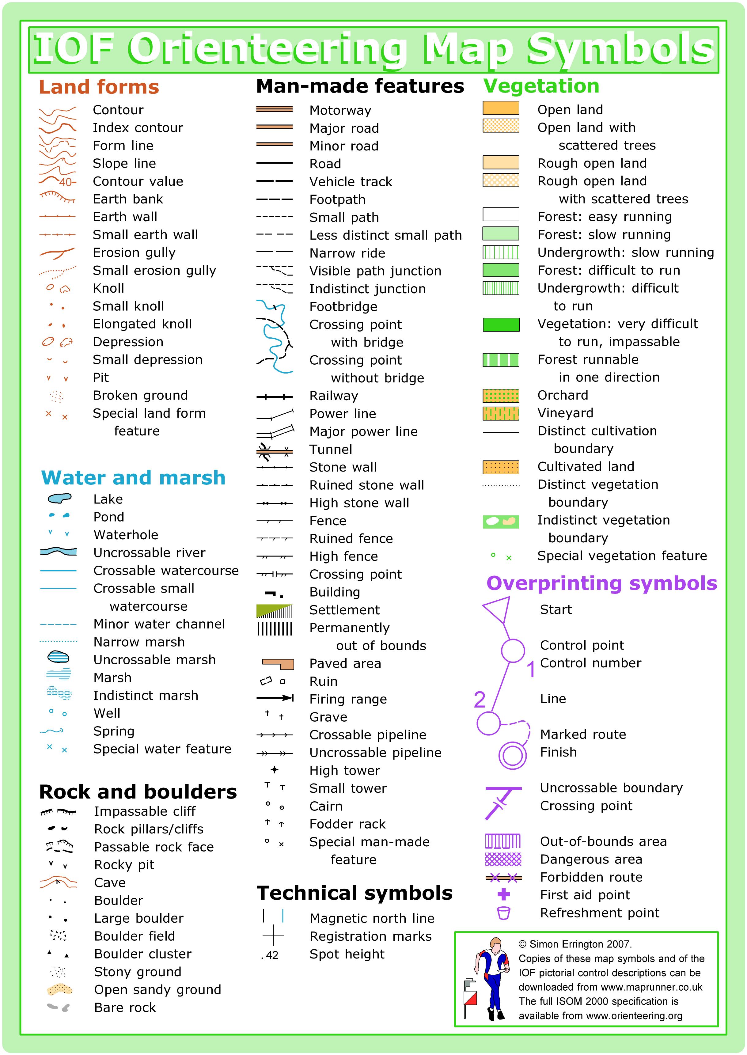
Helpful map reading hints:
· know the difference between “distinct trail junction” and “indistinct” and how they are drawn
· in some places “less distinct” trails are rendered as a continuous thin black line (i.e., no dashes)
· know what the numbers in description sheet column F mean, especially when there are two
There are four out-of-bounds areas on the map. Participants entering them will be subject to disqualification.
Historical trivia: The old-growth forests that covered the areas around Fire Mountain were logged early in the 20th century. The camp’s central north-south road/trail is a former railroad grade, built to haul logs to mills. Two spurs off of this are evident within the map area (the Blue course crosses both, the Red course just one). During construction of the railroad seams of coal were encountered, leading to the establishment of the Blumont Mining Company. Exploration on the hillside above the main railroad grade took place but not enough coal was found for the enterprise to be viable. The interesting topographical features along the hillside are the remains of those efforts.
Course notes
All courses will use a run out start: after punching the Start box, all participants must follow the marked route to the start triangle which is identified in the terrain by an unlabeled control marker (there won’t be anything to punch). Participants must pass between the two white fence posts.
White, Orange Y, Red, and Blue courses: A short ways from the start triangle there is a pile of sheet metal siding (present as of Saturday, February 11th). Please go around it (there will be flagging).
Yellow courses (and possibly others): There are piles of construction materials (rocks and gravel of various sizes) along a most likely route choice. Please DO NOT go over or otherwise on them – please go around.
The Orange through Blue courses will pass near or cross the trails cleared by Ing and Bob. The portions of one of those trails was not cleared beyond the area most likely to used by participants – in the spirit of fairness these uncleared trail sections are marked with purple Xs, “prohibited route”.
The Brown, Green, and Red courses will need to cross a stream. A safe stream crossing has been identified and marked on the map and in the terrain; a route to it from the nearby trail has been flagged. Neither this crossing nor the route are mandatory, just suggested.
Early in their courses, Brown, Red, and Blue course participants might encounter a short (10-15m) section of really nice trail, going from nowhere to nowhere; this trail is not mapped (nor, judging from its appearance, used).
Several controls will have more than one marker and punch box – punch either box, it doesn’t matter which, and the color doesn’t matter either. Red, blue, International Fluorescent Orange, hot pink, they’re all the same (and I wish we had more hot pink punch boxes).
Safety bearing: If on the hillside in the generally eastern area of the camp, head southwestward downhill to the central road/trail and follow it south to the central camp area. If in the flatter lowlands, either head east to the central road/trail and proceed as above, or find the power lines and (in most cases) follow them south to the lake, or if near the lake follow the shore to the central camp area on the northeast side of the lake.
My profound thanks to COC Course Consultant Dave Tallent and OUSA Course Consultant Glen Tryson for their critiques and guidance. In addition, I greatly appreciate Bob and Kathy Forgrave and Ing Uhlin who test ran all of the courses and provided additional suggestions.
I’d also like to thank Michelle Kastner, Winter League Empress, for trusting me to update the map and design the courses … and for Everything Else she has done for the meet, the Winter League series, and for the larger orienteering community.
Have fun!
– Mike Schuh
SCHEDULE
This event is Pre-Registration Only
8:45 am PreRace Training Begins
9 am – Info Tent and Newcomer Instruction Opens
9:35 am – Start process begins
9:45 am – First start
2:15 pm – Last Start
2: 45 pm – Course Closure
PRICES
PUBLIC COURSE PRE-REGISTRATION PRICES
$22 base price
– subtract $5 for CascadeOC members
– subtract $5 for using your own e-punch
Become a member here.
Participating as a group? Just $5 for each additional adult (16+) group
member, no cost for additional minors.
What’s an e-punch?
An e-punch records your race. At each control, you’ll dip the e-punch into an electronic box, which will beep and flash as confirmation. After you finish, you’ll download the e-punch at the download tent and get a receipt that show which controls you visited and how long you took between each; these are your “splits.”
Part of the fun of orienteering is comparing your splits with people who completed the same course, and discussing the routes you took!
SIGN UP
Public registration will close Wednesday 2/15/2023 at 11:59:00 PM.
There is no Day-of-event registration.
Remember to also sign up for a start time for public runners.
LOCATION
PARKING
There is one parking lot at Fire Mountain Scout Camp. It is a 1/3 mile (550m) walk from the parking lot to the event arena.
See site map here.
CARPOOL
Looking for a carpool? Join the Yahoo listserv and share your request to find a ride.
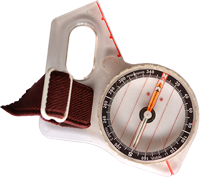
THE MAP
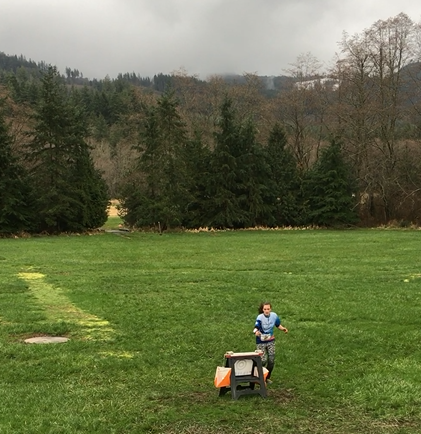
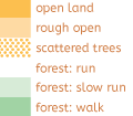
Fire Mountain Scout Camp is rugged terrain with some buildings, a lake, and a power line. Much of the accessible part of this map is hashed green (difficult run) which often translates into “acres of sword ferns”–you can lope through them, but it’s not quite running. And there’s a lot to see in there, including knolls, boulders and rootstocks. There is even a small cave on the property.
Closer in to civilization are a variety of small buildings, clustered in groups. You know you’re at a scout cabin, but which one? Mowed grassy areas are good year-round, but unmowed grass in the open field near the stream tends to get a bit swampy in winter–still traversable, but bring a spare pair of shoes!
Read more on the map page![]()
Click the training icon. I dare you. Don’t be afraid. You will not get a virus (I am pretty sure). C’mon…clickity click.
GOT YA! Now you’re in my web of orienteering training material. Just remember the life you used to know as you fall into a cornucopia of drills, spills, and thrills.
SAFETY & ETIQUETTE
Return to the Finish
All participants MUST return to the finish and download their e-punch or turn in their punch card.
Even if you have not finished your course, you must still return to the the finish and confirm with event staff that you have returned safely.
Out of Bounds
Some areas may be marked out of bounds. It is imperative to respect these boundaries to maintain our relationships with land managers. Participants MUST NOT go out of bounds. Any participant caught going out of bounds will be disqualified.
Course Closure
All participants MUST return to the finish by course closure time. If a participant does not return by course closure, event volunteers will begin coordinating a search party.
If you need a long time on the course, start as early in the start window as possible, wear a watch, and be prepared to cut your course short to make it back by the course closure time.
Whistle
All participants MUST carry a whistle on the course. Complimentary whistles are available at the start tent (please only take one).
If you are injured on the course and need assistance, blow three long blasts to call for help.
If you hear a call for help, abandon your course to find the person in distress.
Voices
Part of the fun and fairness of orienteering is navigating your own course, so please be polite when you find a checkpoint and don’t holler that you’ve found it.


