2023 Ultimate Orienteer #3 – North SeaTac Park (Individual Relay)
 Event #3/8 in the Ultimate Orienteer Series!
Team up with yourself for Ultimate Series #3, an Individual Relay at North SeaTac Park. Depending on your course, you’ll do 2 or 3 legs, picking up a different map each time through the exchange area.
COURSES
Course designer(s): Peter Golde
Details will be provided here once the courses are finalized.
What is my age class?
Individual Relay Course/Class Assignments for Ultimate points
If you want to earn Ultimate points, check the table below to see which category you should sign up for.
For example, if you’re a female 16 or under, your Ultimate age class is F-16 and, for this event, is assigned to the Short course. If you are up for a more challenging course, you can also earn points in F-18 on the Medium course, or F-20 or F-21+ on the Long course. Just keep in mind that other courses are more difficult, both navigationally and physically, and that you’ll be earning points only in the class you sign up for.
| Age Class | Short | Medium | Long |
| F-16, M-16 | |||
| F-18, M-18 | |||
| F-20, M-20 | |||
| F-21+, M-21+ | |||
| F50+, M50+ | |||
| F70+, M70+ |
How are courses measured?
Courses are measured as the crow flies, in a direct line from control to control. Unless you have wings, you will travel farther than this distance! Courses are measured in kilometers, so a good rule of thumb is to simply round up to miles to estimate how far you will go. So in a 5 kilometer race, you’ll likely travel up to 5 miles.
COURSE NOTES
All courses are a single-person (or single-group) race comprised of multiple loops. Beginner and Intermediate have two loops, A and B. Short and Long Advanced have three loops each, A, B, and C. When you check in, you will be given a loop order that you will run, for example, BCA or CAB. Remember your loop order so that you run your loops correctly! You might want to bring some clear tape to combine your course descriptions in the correct order.
Everyone on a particular course will begin at the same time in a mass start. Once you finish your first loop, punch the transition control in the start/finish/map area, drop your first loop map, take the CORRECT map for your next loop, and go!
Be sure to be on time to make the start.
North Seatac Park has two rather different parts, the north and the south, separated by 136th St. Beginner and Short will only use the north, while Medium and Long will each have one loop that is primarily in the south. Crossing 136th may only be done at the marked zebra-striped crosswalk, which is marked on your map and control descriptions as a mandatory crossing point. Please be careful and aware when crossing, as there is no traffic light or flashers.
The soccer and baseball fields are out of bounds (and probably locked), and are marked with purple cross-hatching.
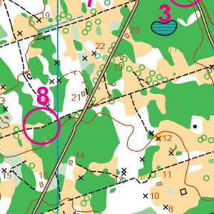
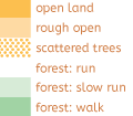
The north half of the park is very flat, open and runnable, with intricate vegetation differences that I have attempted to map correctly. The yellow open is used for mowed grass only. The light yellow “rough open” is not very rough; it is generally un-mowed grass or dirt and can be run at full speed. Most of the white is extremely open and can be run at full speed also. The boundary between rough open and white is often extremely vague and shouldn’t be relied on for navigation. The lightest green is still runnable but has very low underbrush or vines; it’s distinguishable on the ground but you can still very easily run through it. The medium green will slow you down quite a bit, and the darkest green varies from a slow walk, to fight, to completely impenetrable blackberry. The northern part of the park has undergone a lot of clearing of vegetation in the last few years, so the area is much more open and runnable that it was just a few years ago. If you can stay oriented, running cross country will be as fast as paths in most cases, and the advanced courses reflect that.
The southern half of the park has dense forest with a lot of trails. You will probably want to stick to the trails and not try to go cross-country too much, although there are a few places that it might make sense. The vegetation mapping in the southern half is less accurate and hasn’t been updated as recently.
The northern half of the park has an extensive Frisbee golf course on it. The goals (tall metal poles with baskets and chains) are very visible and are mapped with a black triangle, and are very useful for navigation. The launching points are also mapped as small, paved rectangles. You will almost certainly see many people playing disc golf this morning. Please be friendly and courteous, be aware and watch for flying discs, and try not to block the action by stopping where people are trying to throw. The golfers also tend to create paths on the ground. Only the longer and more obvious ones are mapped, and you may have some difficulty seeing the difference between a mapped path and just trampled dirt.
Preliminary course data
| Course | Controls | Total Length | Loops |
| Beginner | 12 | 2.8k | 2 |
| Short | 14 | 3.7k | 2 |
| Medium | 21 | 4.8k | 3 |
| Long | 27 | 6.7k | 3 |
Each course has its own set of loops. For example, the 3 loops on Medium are not the same as the 3 loops on Long.
SCHEDULE
Online pre-registration only!
Online registration closes Thursday April 13 at 9pm.
9:00-10:00 am – Check-in
9:00-10:00 am – Newcomer instruction
10:15 – Pre-race info and transition demo
10:27 am – Long to start line
10:30 am – Mass Start for Long
10:32 am – Medium to start line
10:35 am – Mass Start for Medium
10:37 am – Short and Beginner to start line
10:40 am – Mass Start for Short and Beginner
1:30 pm – Courses close*
*Wear a watch to ensure that you return to the finish by course closure time, even if you have to abandon your course to do so. Those returning after course closure will be disqualified and will make the volunteer staff very grumpy.
PRICES
PRE-REGISTRATION PRICES
$22 base price
– subtract $5 for CascadeOC members
– subtract $5 for using your own e-punch
Participating as a group? Just $5 for each additional adult (16+) group
member, no cost for additional minors.
What’s an e-punch?
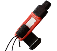
An e-punch records your race. At each control, you’ll dip the e-punch into an electronic box, which will beep and flash as confirmation. After you finish, you’ll download the e-punch at the download tent and get a receipt that show which controls you visited and how long you took between each; these are your “splits.”
Part of the fun of orienteering is comparing your splits with people who completed the same course, and discussing the routes you took!
SIGN UP
LOCATION
PARKING
Parking is available at the park. Carpooling is a always a good idea, as North SeaTac can get crowded on weekends.
CARPOOL
Looking for a carpool? Join the club email group and share your request to find a ride.
THE MAP
North SeaTac Park is a unique park–an answer to the question, “What would happen if all the people and their houses disappeared from a neighborhood?” There’s a mostly intact grid system of overgrown streets, trees and other vegetation that have grown back withe a vengeance, and open, grassy areas with intermittent vegetation clusters that are easy to navigate through if you don’t make a parallel feature error.
We typically start from the northeast area of the park, where there is ample parking and permanent restrooms. There is one busy street mid-course (on the longer courses), which usually has a crossing guard as a volunteer role.
Read more on the map pageSAFETY & ETIQUETTE
Return to the Finish
All participants MUST return to the finish and download their e-punch or turn in their punch card.
Even if you have not finished your course, you must still return to the the finish and confirm with event staff that you have returned safely.
Out of Bounds
Some areas may be marked out of bounds. It is imperative to respect these boundaries to maintain our relationships with land managers. Participants MUST NOT go out of bounds. Any participant caught going out of bounds will be disqualified.
Course Closure
All participants MUST return to the finish by course closure time. If a participant does not return by course closure, event volunteers will begin coordinating a search party.
If you need a long time on the course, start as early in the start window as possible, wear a watch, and be prepared to cut your course short to make it back by the course closure time.
Whistle
All participants MUST carry a whistle on the course. Complimentary whistles are available at the start tent (please only take one).
If you are injured on the course and need assistance, blow three long blasts to call for help.
If you hear a call for help, abandon your course to find the person in distress.
Voices
Part of the fun and fairness of orienteering is navigating your own course, so please be polite when you find a checkpoint and don’t holler that you’ve found it.

