2025-26 Winter League Celebration Weekend Relay – Bellevue College
- Pre-registration only for this event. There is NO day-of-event registration.
- Registration closes on 2/25/26 at 11:59 pm for this meet.
- Mass start at 11 am for first leg.
- Site map will be published here.
Course Distances:To celebrate the end of another successful Winter League season, we are hosting a low-cost 3-person WL Relay on Sunday, March 1st. We hope you join us for the fun and excitement!
Relay teams for this event will consist of three members – all of whom need to register separately. We are offering Open and WIOL categories for this relay, both with a beginner only and a non-beginner option. If all three members of your team are registered in WIOL, you may run in the WIOL category. All others, including mixed-age teams, must run in the Open category. Beginner Relay will have three beginner-level legs. General Relay will have two advanced legs and one intermediate leg. Choose the last option if you need to be paired with a team (remember to fill in your preferred leg).
How it will work:
- Gather your team of three and decide your team name and who is running which leg.
- Legs 1 and 3 will be equal in distance and difficulty. If you choose Leg 1, you will be part of the mass start at 11 am.
- Leg 2 will be easier than legs 1 & 3. Leg 2 will be equivalent to JV Rookie/Advanced Beginner.
- Beginner versions will be of the easiest difficulty.
- If you want to participate but do not have a team you can do that too!
- Everyone registers in the Public Registration system here. When you register:
-
- ONLY if ALL three team members were WIOL runners this season, choose WIOL Relay (Leg 1, 2, or 3).
- All others choose OPEN Relay (Leg 1, 2, or 3).
- There are no other restrictions when forming a team.
- Be sure to tell us your team name and list of teammates when you register.
- If you want to participate but do not have a team, just choose the seventh-course option “I don’t have a team, please pair me up” and we will do that for you.
COURSES
Course designer(s): Nancy Devine
Course Distances:
- Beginner legs: 1.1 Km, 13 controls
- Intermediate legs: 2.1 Km, 17 controls
- Advanced legs: 2.9-3.0 Km, 22 controls
How are courses measured?
Courses are measured as the crow flies, in a direct line from control to control. Unless you have wings, you will travel farther than this distance! Courses are measured in kilometers, so a good rule of thumb is to simply round up to miles to estimate how far you will go. So in a 5 kilometer race, you’ll likely travel up to 5 miles.
COURSE NOTES:
Welcome to the Bellevue College Celebration Weekend Relay! We have some fun courses planned for you. New this year, we are including an all-beginner relay! This is an opportunity for elementary age students and parents who haven’t orienteered before to team up to compete on a course that is appropriate for their skill level. The other relay is the same format we have used for several years – two advanced legs and one intermediate leg. The advanced legs include forking so don’t assume that you can just blindly follow the person I front of you!
At first glance, Bellevue College seems like many of the other community colleges that we have mapped, like North Seattle College, South Seattle College, Edmonds College, and Shoreline College. The area is generally pretty flat, buildings and sidewalks are generally aligned on a grid, there are huge parking lots, and there is some green space and sports fields around the edges.
All of this holds true at Bellevue College, except the heart of campus features a complex of six large buildings, interconnected with 2nd-level skybridges, balconies, breezeways, open-air interior corridors and staircases. In total, there’s over 1 kilometer of 2nd-level pathways here, with another 1 kilometer of pathways underneath. But don’t assume that the upper level is a duplicate of the lower level. Some passageways only go through on the upper level, some only go through on the lower level, and some go through both. And dead-end hallways oftentimes don’t have the same lengths on the upper level vs. lower level.
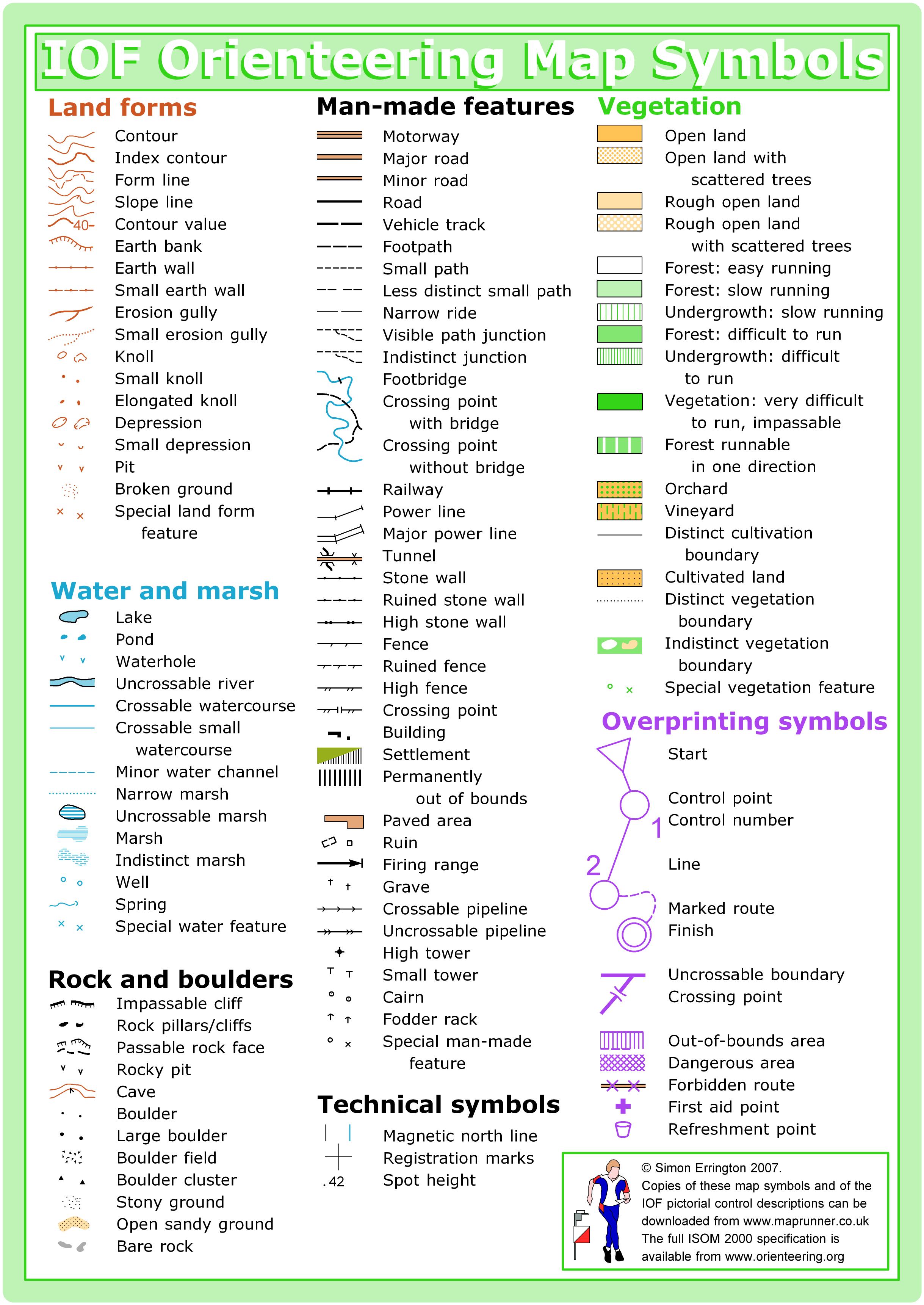
The latest mapping standard for “sprint” orienteering has three symbols to make mapping this complex area possible.
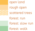
· White diagonal crosshatching. If you see this pattern, that means that there are two levels here. The colored part of the pattern shows what is on the upper level (usually a canopy, but it can also be under-the-sky concrete or a solid building). The white part of the pattern just shows that there’s another level underneath, which is almost always runnable concrete. (512.3 – Area runnable at lower level, see p. 23 here for a visual representation.)
· A line of black “sharkteeth.” If you see this, it means two very different things: it’s passable if you’re on the lower level, and it’s not passable if you’re on the upper level. This is used extensively on the map because of all of the skybridges and balconies (you can run on them and under them). If you’re approaching a line of sharkteeth from the “pointy” side of the teeth, then you can go under. If you’re approaching a line of sharkteeth from the “top” side of the teeth, there’s a wall or railing preventing you from getting down. Note: there are many locations where
there is olive green adjacent to the open side of the lower-level passageways. The “sharkteeth” are shown to indicate that the sides are open, but you cannot enter the passageway through the olive green. (512.1 – Bridge or tunnel entrance, see p. 22 here for a visual representation.)
· A line of black square dots. This shows you where building walls and passageways are on the lower level only, and you will only see this symbol in conjunction with the white diagonal crosshatching. (512.2 Underpass or tunnel, see p. 22 here for a visual representation.)
Thankfully, everything in this area of campus is just on two levels, which makes for an unambiguous map. The beginner relay and Leg 2 of the other relay stay only on the lower level. Runners on legs 1 and 3 of the relay will be challenged a few times with detailed multi-level map reading! Use the resources above to make sure you understand what you’ll encounter!
Complex? Yes. Ambiguous? No. If you ever find that you’re on the wrong level, just find some stairs. There are 17 staircases that connect the upper and lower levels of this area! You will also need to know how to read all the columns of your control descriptions! Columns C and G will be particularly helpful in the campus area. Pages 6 and 14-16 here explain all the options for Columns C and G.
Speaking of stairways, many of their shapes (and the immediate building geometries surrounding them) are simplified a little bit to aid in map legibility. Also on the subject of map legibility: there’s a lot of urban stuff on a campus, things like picnic tables, benches, light poles, garbage cans, fire hydrants, signposts, and power lines. If these were all mapped, it would be a bunch of clutter, so they’ve all been omitted. Very large utility boxes and air conditioners have been mapped as buildings (at their minimum size). Smoking shelters are mapped as buildings.
Also, again to aid in legibility in tight spaces, many “tags” have been removed from passable fences, railings, and retaining walls. If it’s a thick black line, it’s uncrossable, but if it’s a medium black line, it is ok to cross.
Since the last time we ran on the Bellevue College map, the college has done some extensive landscaping work. Many of the landscaped areas that were previously mapped as rough open areas are now mapped as out of bounds using olive green (520 – Area that shall not be entered). Do not enter or even step/jump across olive green areas! It is grounds for disqualification. The adjacent neighborhood is mapped as olive green, but you can run on the streets there. The sports fields, the 5-story parking garage, and a large construction area are also out-of-bounds.
SCHEDULE
SCHEDULE:
9:30 am Team check-in opens
10:00 am Beginner instruction opens
10:30 am Team check-in closes
10:40 am Beginner instruction ends
10:45 am Pre-start briefing; demonstration of exchange procedures
11:00 am Mass start
- 11:45 am Leg 2 mass start if your teammate is not back to tag you
- 12:30 pm Leg 3 mass start if your teammate is not back to tag you
1:45 pm Course Closure
This event will be a mass start at 11 am, with other mass starts as needed if a team’s runner has not returned yet.
PRICES
PRE-REGISTRATION PRICES
$3 or 1.5 volunteer points = base price (Cascade OC members and non-members, with or without e-punch rental)
What’s an e-punch?
An e-punch records your race. At each control, you’ll dip the e-punch into an electronic box, which will beep and flash as confirmation. After you finish, you’ll download the e-punch at the download tent and get a receipt that show which controls you visited and how long you took between each; these are your “splits.”
Part of the fun of orienteering is comparing your splits with people who completed the same course, and discussing the routes you took!
SIGN UP
PRE-REGISTRATION PRICES
$3 or 1.5 volunteer points = base price (Cascade OC members and non-members, with or without e-punch rental)
- Registration closes on 2/25/26 at Noon for this meet.
LOCATION
GETTING THERE AND PARKING
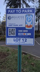
- Access from Landerholm Circle, off 148th Ave SE.
- Use Parking Lot 8 or 10.
- Address: 8, 10 Coal Creek Rd, Bellevue, WA 98007
- You will need to pay $3 for parking, either online or at one of the parking meters: https://bcparking.aimsparking.com/
SITE MAP 2025-26 Winter League Celebration Weekend Relay at Bellevue College (1)
CARPOOL
Looking for a carpool? Join the club email group and share your request to find a ride.
THE MAP
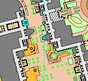
Situated just north of I-90 between Factoria and Lake Sammamish, Bellevue College is a fun little campus that’s fairly standard but includes one particularly notable feature – a series of elevated outdoor walkways which connect the main 8-10 buildings of the campus core. Reminiscent of North Seattle College, these walkways significantly enhance the orienteering complexity and navigational challenge of the venue by adding a third dimension to potential control locations and route choice options. Beyond this, the map includes various other buildings, sports fields, and parking lots.
Read more on the map pageSAFETY & ETIQUETTE
Return to the Finish
All participants MUST return to the finish and download their e-punch or turn in their punch card.
Even if you have not finished your course, you must still return to the the finish and confirm with event staff that you have returned safely.
Out of Bounds
Some areas may be marked out of bounds. It is imperative to respect these boundaries to maintain our relationships with land managers. Participants MUST NOT go out of bounds. Any participant caught going out of bounds will be disqualified.
Course Closure
All participants MUST return to the finish by course closure time. If a participant does not return by course closure, event volunteers will begin coordinating a search party.
If you need a long time on the course, start as early in the start window as possible, wear a watch, and be prepared to cut your course short to make it back by the course closure time.
Whistle
All participants MUST carry a whistle on the course. Complimentary whistles are available at the start tent (please only take one).
If you are injured on the course and need assistance, blow three long blasts to call for help.
If you hear a call for help, abandon your course to find the person in distress.
Voices
Part of the fun and fairness of orienteering is navigating your own course, so please be polite when you find a checkpoint and don’t holler that you’ve found it.


