Ultimate Orienteer #7 – Goat
Part of the Ultimate Orienteer Series, COC’s variety pack of orienteering events.
Join us for a goat event in the forests of Salmon La Sac. The final COC (#7!) event in this year’s Ultimate Orienteer Series, we’ll offer three long-distance courses with a twist: skip 1 or 2 controls (depending on which course you do) of your choice.
The Goat is part of 2 days of orienteering in eastern Washington. Enjoy a Middle Distance event at Indian & Jack Creek on Saturday.
Find out more about Goat events!
Skipped Controls
As is often the case in a Goat event, you are permitted to skip one or more non-consecutive controls, depending on which course you do. Following is permitted.
Zygoat – 1 skip
Kid – 2 skips
Goat – 2 skips
PLEASE pre-register online if you consider going to this event so we can get a better map count. Since there are mass starts, we cannot reuse the maps.
COURSES
Course designer(s): Dave Tallent, Kean Williams
Big thanks to Nikolay Nachev for flagging control locations and to Jourdan Harvey and Celia Schofield for setting controls and water!!
Zygoat (intermediate navigation) – skip 1 control – 3.5 km, 11 controls, there is some climb (50 m)
Kid (advanced navigation, Jr. and Masters) – skip 2 non-consecutive controls – 6.9 km, 15 controls, quite a bit more climb (200 m)
Goat (advanced navigation, Open) – skip 2 non-consecutive controls – 12.3 km, 29 controls, a lot of climb (350 m)
There is no beginner course at this event.
How are courses measured?
Courses are measured as the crow flies, in a direct line from control to control. Unless you have wings, you will travel farther than this distance! Courses are measured in kilometers, so a good rule of thumb is to simply round up to miles to estimate how far you will go. So in a 5 kilometer race, you’ll likely travel up to 5 miles.
COURSE NOTES
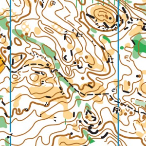
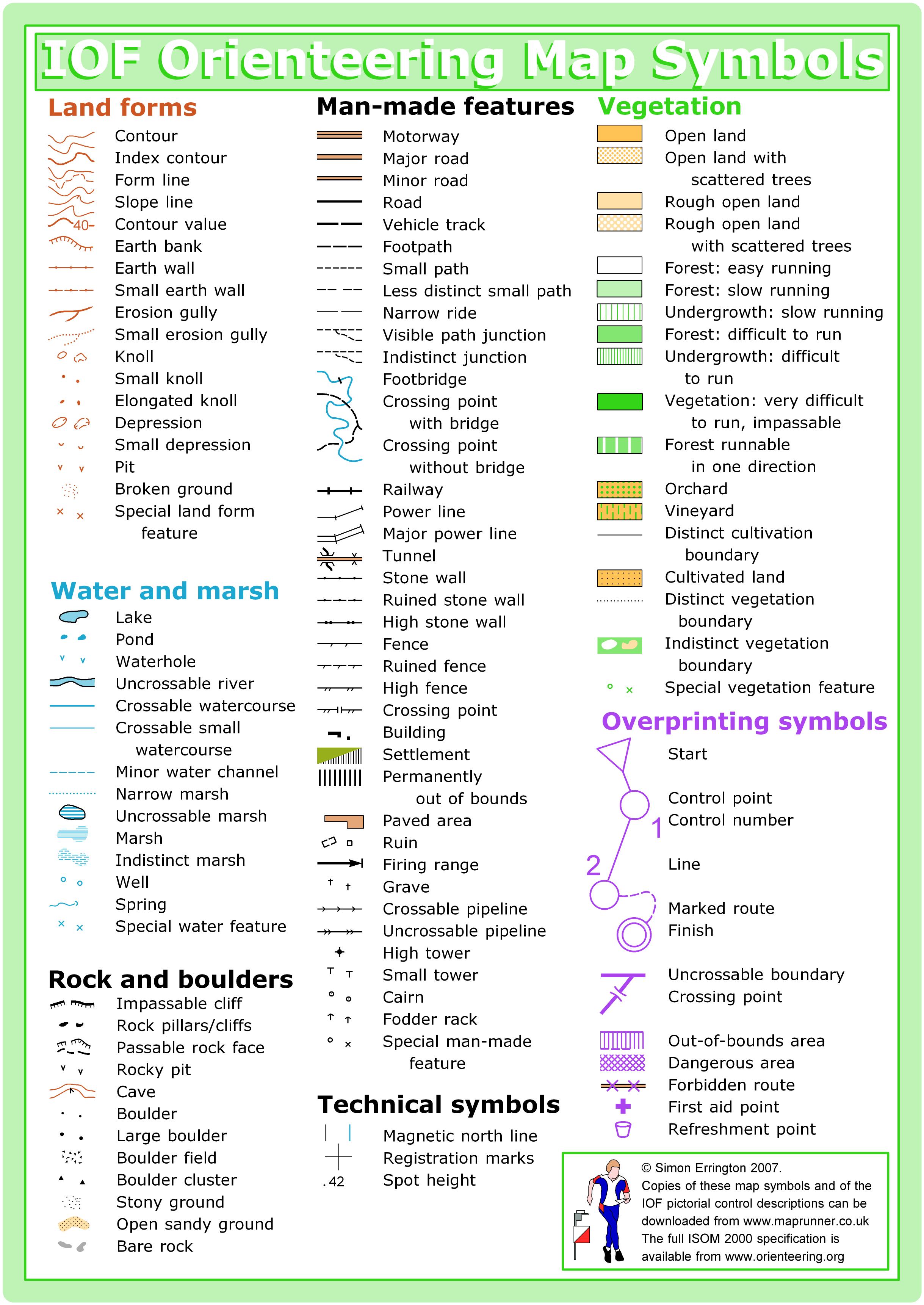
Salmon La Sac is beautiful, rugged, and navigationally complex. There are many reasons why this venue tops the scales at 10/10 in both of CascadeOC’s physical and navigational ratings! The terrain consists of open runnable forest, giant slabs of rock, thousands of knolls, boulders, and cliffs, and some thicker areas of vine maple, downfall, and logging debris. Salmon La Sac poses a significantly greater technical and physical challenge than an average orienteering meet on a college campus or in a city park.
The Intermediate course will require basic contour reading, and will have most checkpoints within 100 meters of trails and roads. The two advanced courses (Short Advanced and Long Advanced) will be almost entirely off trail, requiring detailed contour reading, and precise navigation to point features.
All maps are 1:10000 scale with a contour interval of 5m and will be printed on waterproof paper. The Long Advanced and Short Advanced courses will be printed on 11″x17″ paper, while the Intermediate course is on 8.5″x11″ paper.
Start
Maps will be handed out and timing will begin near the registration area. You’ll then follow a marked route approximately 100 meters to the start marked on your map (there is no start punch).
Water
We’ll have water available in the parking/registration area. There will also be water available on the Long Advanced and Short Advanced courses, at one control that you’ll visit twice on each course. It is still advisable to carry water with you on the course, especially if it is hot!
Safety Bearings
If you need to exit to safety, there are two different safety bearings for the two areas of the map. If you’re north of the out-of-bounds, then you’ll want to head south/downstream to the road, which will get you to the road or trailhead. If you’re south of out-of-bounds, you’ll want to head west to the Cle Elum River Road. These are noted on the maps.
Terrain & Map
This map was originally made in 2009 and is in generally good shape. The most recently logged areas have grown somewhat over the years, so mapped areas of rough open land with scattered trees can seem more light green in reality. There is vine maple in the deeper reentrants, but courses are designed around the worst of it (and they don’t have thorns, so it’s not too unpleasant). A lot of the map has quite nice and runnable woods and moss-covered slabs of rock!
Speaking of rock, there’s a lot of it, in many different forms. Giant slabs of moss-covered rock are mapped as open land. There are thousands of boulders, cliffs, and rocky knolls, not all of which are mapped. Boulders smaller than 1m in height are usually not mapped. Some rocky slopes (some covered in moss, some not quite steep enough) are not mapped as cliffs, just as contour lines. I’ve used a lot of rock features as control location on the advanced courses.
SCHEDULE
Registration: 8:00-8:45am
Goat Map Handout: 8:50am
Goat Mass Start: 9:00am
Kid/Zygoat Map Handout: 9:05am
Kid/Zygoat Mass Start: 9:15am
Course closure: 2:30pm*
Newcomer instruction: 8:00-8:30am
*Courses at Salmon La Sac often take people much longer than they expect. Select a course that’s compatible with your navigational skill. Also, wear a watch to ensure that you return to the finish by course closure time, even if you have to abandon your course to do so. Those returning after course closure will be disqualified and will make the volunteer staff very grumpy.
PRICES
PRE-REGISTRATION PRICES
$17 base price
– subtract $5 for CascadeOC members
– subtract $5 for using your own e-punch
DAY-OF-EVENT REGISTRATION
$20 base price
– subtract $5 for CascadeOC members
– subtract $5 for using your own e-punch
What’s an e-punch?
An e-punch records your race. At each control, you’ll dip the e-punch into an electronic box, which will beep and flash as confirmation. After you finish, you’ll download the e-punch at the download tent and get a receipt that show which controls you visited and how long you took between each; these are your “splits.”
Part of the fun of orienteering is comparing your splits with people who completed the same course, and discussing the routes you took!
SIGN UP
Online pre-registration closes: Thursday, June 7 at 9pm
Day-of-event registration is available by cash or check, made payable to Cascade Orienteering Club
LOCATION
PARKING
Parking will be in the sno-park lot off Forest Road 4315.
Registration, start, and finish will take place in or near the sno-park lot.
CARPOOL
Looking for a carpool? Join the Yahoo listserv and share your request to find a ride.
THE MAP
Salmon La Sac is Cascade’s most challenging map of all, both physically and navigationally.
The glaciated terrain produces incredibly detailed topographic features, which orienteers on Advanced courses must rely on, since trails are sparse. Plus, there are hundreds (thousands?) of point features, requiring detailed navigation to find. Add to that, Salmon La Sac is the steepest venue in the Cascade map catalogue, and off-trail travel is rocky and uneven.
Salmon La Sac is a beast of a venue, but it is also one of the most beautiful. High points on the course can surprise you with long vistas, and clearings are often bare rock covered in springy moss that you’ll want to stop and have a picnic on.
You may take much longer on a course at Salmon La Sac than you could have imagined, but if you bring water and snacks, it will be a welcome adventure.
Read more on the map pageSAFETY & ETIQUETTE
Return to the Finish
All participants MUST return to the finish and download their e-punch or turn in their punch card.
Even if you have not finished your course, you must still return to the the finish and confirm with event staff that you have returned safely.
Out of Bounds
Some areas may be marked out of bounds. It is imperative to respect these boundaries to maintain our relationships with land managers. Participants MUST NOT go out of bounds. Any participant caught going out of bounds will be disqualified.
Course Closure
All participants MUST return to the finish by course closure time. If a participant does not return by course closure, event volunteers will begin coordinating a search party.
If you need a long time on the course, start as early in the start window as possible, wear a watch, and be prepared to cut your course short to make it back by the course closure time.
Whistle
All participants MUST carry a whistle on the course. Complimentary whistles are available at the start tent (please only take one).
If you are injured on the course and need assistance, blow three long blasts to call for help.
If you hear a call for help, abandon your course to find the person in distress.
Voices
Part of the fun and fairness of orienteering is navigating your own course, so please be polite when you find a checkpoint and don’t holler that you’ve found it.


