Winter League #7
For safety reasons we are cancelling Saturday’s Winter League #7 meet at Pt. Defiance.
-
We will be counting the Championship race at Camp River Ranch as the 7th meet of the season. So those close races for season trophies will be decided on the course and not by snow.
-
The Camp River Ranch meet will still be a championship race with trophies for this meet, but it will also count as meet 7 in the overall season standings.
A huge thank you to Ing Uhlin and Dave Tallent for the incredible amount of work they put in to design amazing courses for Pt. Defiance. We will use these courses in the near future, so they will not go to waste!
Winter League is the Pacific Northwest’s premier competitive orienteering series for all ages. Elementary, Middle School, and High School students compete under the banner of the Washington Interscholastic Orienteering League (WIOL). Cascade Orienteering Club also offers a competitive league for college students and adults, as well as non-competitive beginner-friendly categories at every event!
COURSES
Course designer(s): Ing Uhlin and Dave Tallent
|
Course |
Controls |
Length |
Climb |
| Beginner/Elementary |
8 |
1.6 km |
40 m |
| Middle School |
8 |
2.5 km |
40 m |
| Intermediate / JV Girls |
10 |
3.2 km |
50 m |
| JV Boys North |
9 |
3.1 km |
65 m |
| JV Boys South |
11 |
3.0 km |
65 m |
| Varsity |
11 |
4.0 km |
80 m |
| Short Advanced |
13 |
4.6 km |
100 m |
| Long Advanced |
13 |
6.6 km |
130 m |
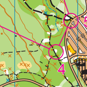
How are courses measured?
Courses are measured as the crow flies, in a direct line from control to control. Unless you have wings, you will travel farther than this distance! Courses are measured in kilometers, so a good rule of thumb is to simply round up to miles to estimate how far you will go. So in a 5 kilometer race, you’ll likely travel up to 5 miles.
COURSE NOTES
General information:
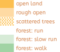
- Map has had a major update – especially point features and trails. However, vegetation colors are not accurate.
- The run-ability of light green versus dark green vegetation may be inaccurate.
- The white areas are open and do offer enjoyable and fast routes.
- Many of the previously mapped knolls are in fact stumps.
- Recent windstorms have made runnable areas likely less so (due to blowdown), and created unmapped rootstocks.
- But the basic rule is: if it’s dark green, stay out.
- Courses routes
- There are several opportunities to choose an off-trail route.
- Legs were chosen to avoid unfriendly bush whacking.
- We encourage you to avoid roads and use parallel trail routes.
- We have designed the courses to emphasize a fun experience, but also to test your orienteering skills.
- Legs were chosen to test these skills: compass; handrails and catching feature; attack points; pace counting; aiming off; using vegetation boundaries as handrails; and control extensions. Do you know your pace count for 100 m?
- Mandatory Crossing Points
- If you have a crossing point on your control description or course map- it is MANDATORY. Not using a mandatory crossing point may result in a DQ.
Safety Info for courses JV Girls /Intermediate /Varsity /Short Advanced /Intercollegiate /Long Advanced Only:
- Where a trail is considered to be dangerous it is indicated on the map as follows:
- “Danger – Do Not Use!” = you MUST NOT GO THERE.
- “Warning – Caution if using this trail section” = it is recommended you do not take this section, but if you do take this trail you should walk carefully and not run.
Safety Info in General:
- Do not horse play near cliffs.
- Be diligent at road crossings.
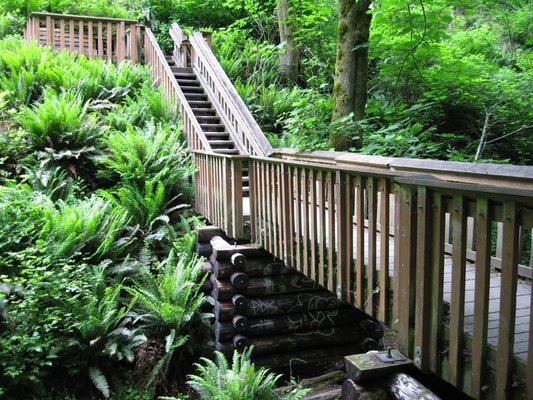
Beginner/Elementary
Course 1 is a loop trail run. Apart from the manned pedestrian road crossing, there are no further road crossings. Safety was our first priority. The first leg is flagged and must be followed. Along the course there will be plenty of opportunity to observe point features located along the trails: stumps; rootstocks; and fire hydrants. Familiarize yourself with these symbols
Placements of controls are visible from the expected direction of travel, and the placement “pulls” participants onto the next handrail (trail). Control markers have been placed at every decision point (except the final two legs) and hence there is only one route-choice, one decision point. The final two legs, a route choice must be made. This will prepare participants for the next level, where route choice will be the norm.
Skills: direction of travel, handrails and catching feature (which will be another trail)
Middle School
Course 2 is a trail run but with several route options for most legs.
Control placements are a few meters off the trail but visible from the trail and direction of travel. However, near the end of the course, the controls, although very close to the trails, will not be visible. Also, very short forest travel will be an option. This will prepare participants for the next level, where route choice, controls not visible, and off-trail will be the norm.
Skills: direction of travel, handrails and catching feature. Picking the safest route. Keen observation. The marker is often placed behind the feature. Read control description for control placement.
Intermediate/JV Girls
This course offers several opportunities to go off-trail. However, there are two legs when one will be on a road. Not fun. Some trails have fallen branches and downed trees. There are trails located on a cliff edge. This course should heed the safety instructions above.
Control placements are a few meters off the trail but not visible. Read your control description.
Skills: direction of travel, handrails, catching feature, pace counting (do you know how many steps it takes you to run 100 m?) and looking for definite attack points. Picking the safest route and keen observation are essential. The markers are often placed behind the feature. Read the control description for control placement.
JV Boys- North and South
These courses offer multiple route choices and opportunities to run off-trail. One leg has eight micro routes! But which is the safest? Some trails have fallen branches and downed trees.
Control placements are a few meters off the trail but not visible. Read your control description.
Skills: direction of travel; handrails; catching feature; pace counting (do you know how many steps it takes you to run 100 m?) and looking for definite attack points. Picking the safest route and keen observation are essential. The marker is often placed behind the feature. Read the control description for control placement.
Varsity, Short Advanced and Long Advanced
These courses offer fast trail running, route choices, and opportunity to go off-trail, even for a short distance. Courses 6 and 8 are physical. Considering the audience for course 7, we have erred on the side of less physical and a tad easier. These courses should heed the safety instructions above.
Control placements are several meters off the trail but not visible. Read your control description.
Skills: direction of travel, handrails; catching feature; pace counting; looking for definite attack points; aiming off; control extension and picking the fastest but safest route.
SCHEDULE
9:30am – Registration opens & Newcomer instruction available
10:00am – Start opens
11:00am – Newcomer instruction ends
11:30am – Registration closes
Noon – Start closes
3:00pm – Course closes
Why is there a start window?
This event uses an interval start, which means that participants are started in waves instead of all at once. When you arrive at the start tent, find the chute for your course and follow the start volunteer’s instructions.
PRICES
Elementary, Middle School, Junior Varsity, and Varsity Students
Pre-Registration: $45 for all 8 events
Day of Event: $10 (cash or check only)
WIOL Admin Fee (once per season): $5 before October 13, $15 after.
Subtract $10 from the season pass if you own your own e-punch.
Intercollegiate Students, Adults, and non-competitive courses
Pre-registration: $17 (until Thursday 9pm)
Day of event: $20 (cash or check only)
Subtract $5 for Cascade OC members
Subtract $5 for using your own epunch
Get one event free if you pre-register for the entire season.
Become a Cascade OC member for $5-20
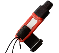
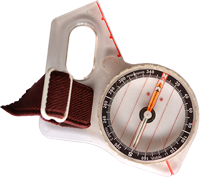
What’s an e-punch?
Orienteering uses RFID-like technology known as e-punch to record your race. At the start, finish, and each control, you’ll dip the e-punch into an electronic box, which will beep and flash as confirmation.
At the finish tent, download your e-punch to get your results (and let us know you’ve returned safely), then compare your splits and discuss your routes with other finishers!
You can rent an e-punch from Cascade OC , or buy your own from Wildwood Adventure Outfitters.
SIGN UP
Students with a season pass, use the button above to RSVP for this meet by Tuesday February 5 at Noon.
LOCATION
Parking:
Will be in the various lots on Owen Beach Road and at Owen Beach.
CARPOOL
Looking for a carpool? Join the Yahoo listserv and share your request to find a ride.
SAFETY & ETIQUETTE
Return to the Finish
All participants MUST return to the finish and download their e-punch or turn in their punch card.
Even if you have not finished your course, you must still return to the the finish and confirm with event staff that you have returned safely.
Out of Bounds
Some areas may be marked out of bounds. It is imperative to respect these boundaries to maintain our relationships with land managers. Participants MUST NOT go out of bounds. Any participant caught going out of bounds will be disqualified.
Course Closure
All participants MUST return to the finish by course closure time. If a participant does not return by course closure, event volunteers will begin coordinating a search party.
If you need a long time on the course, start as early in the start window as possible, wear a watch, and be prepared to cut your course short to make it back by the course closure time.
Whistle
All participants MUST carry a whistle on the course. Complimentary whistles are available at the start tent (please only take one).
If you are injured on the course and need assistance, blow three long blasts to call for help.
If you hear a call for help, abandon your course to find the person in distress.
Voices
Part of the fun and fairness of orienteering is navigating your own course, so please be polite when you find a checkpoint and don’t holler that you’ve found it.


