Samples of the map will be provided after its initial use.
Credits:
The map of Fisk State Park was made by John Brady with the help of the following team: Ben Brady, Sherri Brady, Ben Conley, Ben Cooper, Jack Barkley, Greta Leonard, Alexis Leonard, and Dave Tallent. John and Dave used the opportunity to bring mapping to a newer generation, and a good portion of the field work was done and verified by high-schoolers on their spring break!
General Notes:
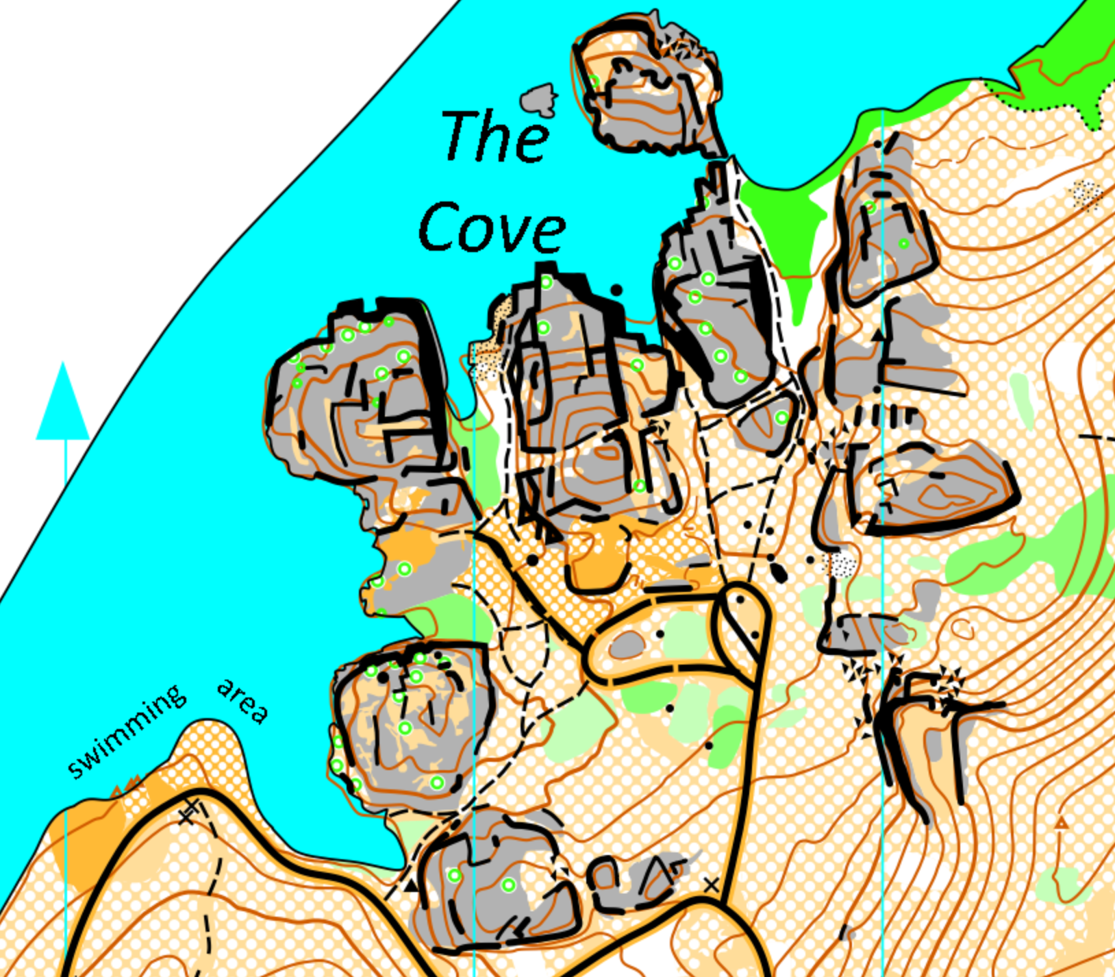
Fisk State Park resides along the Spokane River in an area where the dam downstream of the park has created a large body of water called Long Lake. The area is characterized by open forests in most areas, and extremely intricate rock formations throughout the area. The rock formations are what make the area so unique and special. Many of these rocky areas can be enormous in scale (>50′ cliffs), however there is almost always a way to get in, up and among them, even if it is a bit of a maze to figure out how to do so. In between the large rocky formations are deep valleys resembling slot canyons in some instances. These valleys have much thicker vegetation, but often have indistinct trails penetrating the vegetation. Much care has been taken to try and depict passibility in both the canyons as well as among the rocky areas/cliffs/high ground. These subtle conventions used will be described in the details below. A significant note must be given at the point (and I apologize for being the guy who has to add “safety talks” to everything…I agree it is annoying): because the park is littered with cliffs, it is extremely dangerous! Be careful at all times!! You must see everywhere you intend to go, or risk injury or even death (as with all cliffs).
Due to the intricacy of the map and terrain, it was decided to make the map in a scale that the features were most mappable and thus readable: 1:4000 / 2.5m contours. This is not a typical scale for an exclusively forest map, however I firmly believe this map could not have been done in a smaller scale such as 1;10,000 without removing needed detail in the interesting areas of the park. I hope you agree.
When navigating in this area there are a few things to be aware of. When approaching the rock formations from the forest, if you are even a little off of your intended angle of approach, it will be extremely confusing, as all of the rock formations will look very similar…perhaps indistinguishable. As a result, it will be very easy to get lost or pulled off by another control that isn’t yours. Young children should really consider being with their parents in this terrain due to the likelihood of becoming very lost or wandering unattended among the dangerous cliffs. Also, it is a good idea to treat each leg similar to how you would treat a complex sprint course leg – look for unseen complexities on the route before committing. It will likely save your butt in the end. Lastly, relocation is likely to happen to everyone to some degree. Luckily, there are a plenty of distinct linear features such as hillsides, water, some roads, and giant valleys to help you get straightened out.
Mapping Conventions:
The main emphasis on the map was to try and find ways to depict the most obvious features that exist in this forest: raised rock formations. The forest is basically a thinned-out pine forest, interrupted with granite formations that can vary from small to absolutely mammoth in size. These are generally represented with the grey symbol for bare rock. However, it is important to note that the rock in this park is not always “bare”. Often it has a mossy-grass that has grown on it which provides surprisingly decent traction on most places. There are also trees that are growing among the rock formations throughout. An effort was made to place the rough-open or rough-open with scattered tree symbol in the valleys of these rock formations in order to better highlight passable areas and low areas among these cliffs. Highlighting these lower areas with these symbols tends to help visually show the true shape of these complex structures a bit. However, in many places where a choice had to be made to show either the trees or the higher ground caused by rock formations, the rock formations were depicted as they are the more dominant feature.
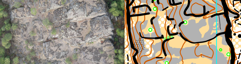
Depicting cliffs, stones, boulders, boulder clusters, boulder fields, or bare rock is quite the fuzzy transition from one to another. A seasoned orienteer will no doubt understand this, but a slightly inexperienced orienteer may look at a field of large stones and think “that’s a boulder field” until later coming upon 20 car-sized rocks only to re-evaluate their original thought. Just keep this in mind as the entire map is basically working under these constraints. With that said, some of the guidelines we tried to use:
-Small boulder: >1m but < 2m in size. This criteria may have been eased in places where there is nothing else around but an obvious boulder, but in general it is good. A single boulder is a rock that stands alone and is not really part of a granite formation or originates from deep underground. Amongst the cliffs, only distinct boulders are mapped and the criteria became much more stringent.
-Large boulder: >2m, but <3m in size. A single boulder is a rock that stands alone and is not really part of a granite formation or originates from deep underground.
-Gigantic Boulder: >3m in size. Can be construed as a large piece of granite, but there is no practical way to get up or on it for navigation purposes. This is an all black “blob” in the shape of the huge rock.
-Stony ground (normal and dense): Areas where there are a bunch of rocks on the ground and are useful for either determining your location (due to absence of other features) or useful for considering running speed. There are quite a few areas where this is depicted, but other areas in the park where it was not mapped because it just wasn’t distinct enough as a field of stones to warrant a bunch of dots on the map.
-Boulder cluster: a few boulders bigger than the boulder dimensions, that are too close to be mapped individually. Small and large.
-Boulder field: Either just a bunch of boulders spread out over a large area, or perhaps an area amongst the granite cliffs that is very “crumbly” and non-homogeneous and thus didn’t deserve to be ignored or shown as grey “rock”.
-Although there are many boulders depicted, an attempt was made to depict large stones that are embedded in the ground as bare rock rather than as individual boulders. Individual boulders were attempted to be depicted as >1m and as stand alone items in the forest and not part of the land itself. In many instances, boulders and large rock (depicted as grey areas) are similar.
-Passable Cliff: Often used to help highlight distinct edges that you could climb over if you wanted to, and not die. Although many of these are marked, there are many passable cliffs that one might say could be marked as well. The minimum height of a passable cliff was done completely by human interpretation of whether or not it was distinct and they felt they could safely pass it. Often it melts into and out of an impassable cliff. No cliff directional tags are shown on the map anywhere.
-Impassable Cliff: These have been evaluated to be either dangerous, or deadly. Make plans to avoid these. In some instances, there are cliffs approaching 120′, in other places it may only be 2m high or just a very steep yet long slope that you don’t want to be on. An effort was made to make some of the higher cliffs have a slightly thicker cliff symbol (actually the gigantic rock symbol was used to exaggerate the cliff symbol), but due to the close proximity of all the symbols on the map, often the cliff symbol alone is shown, but is not enough to give you the full appreciation of the size of one cliff vs. another one. Use the contours to help with this.
-Contours: All contours are 2.5m. Many of the contours were hand edited, but there is no way contours alone can depict the complexity of the cliff walls and random shapes this type of terrain provides. Some form lines were used here and there, but not many. Regardless, when in the forest, don’t let the flatter areas with form lines lull you into looking for something distinct when in fact it is really subtle.
-The forest was “thinned” in 2023 to 2024. There are many many many areas where the forest thinning has resulted in unintentional roads in the forest. There are so many of these and they are so random and dominant, that it was decided to not include the tracks left behind from these machines, even if they are in some places very significant. This is because the map would have been nothing more than a blur of black lines everywhere and dominated the map, despite these tracks not being the ideal items to navigate off of. Instead, yellow stripes indicate rough open area are placed on the map in these locations.
-The forest was mapped in late winter / early spring. In May, grass grows high obscuring all trails to some degree. If you run in late May through the summer, expect the vegetation to be a wee bit more gnarly.
-Old jeep roads / trails represented by narrow ride with light yellow under-color.
That is about all of the map notes I can think of for now. Hopefully you enjoy it to at least some degree:)
Very Respectfully,
John Brady
Note: Samples of the map are provided here for educational purposes only; the map shown here is not kept up-to-date.
The purpose of providing these navigational and physical ratings below is to provide greater context for how challenging an orienteering course at this venue might be. For example, an advanced-level course at a local city park will be easier to complete than an advanced-level course in the mountains.