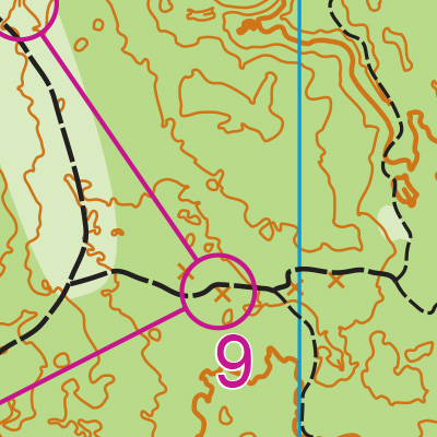
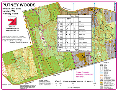
The Putney Woods map is all woodsy trails, with widespread underbrush alongside, reminiscent of Bridle Trails. But there are several key differences. First, there are areas of lighter vegetation in light-green areas that are accessible off-trail, offering a wider degree of navigational options, especially for more advanced navigators.
Novice orienteers should be aware that the northern part of the map doe not have a street border; it is directly adjacent to Saratoga Woods park, making it possible to end up off-map with a single turn onto the (one and only) wrong trail. (Note to course-setters: This is a good place for an out-of-bounds sign during the event).
Many trails follow an almost grid-like patterns, making parallel feature errors possible, while others in hilly areas wind almost randomly up and down terrain. There are plenty of areas to practice contour recognition. One area to watch out for is the center-south part of the map; several trails lead into this open, appealing navigational area–but it is private property and should be avoided! (Note to course setters: Another good place for out-of-bounds signs).
Turn-by-turn directions:
FROM THE SOUTH (SEATTLE, EVERETT):
The shortest route includes a FERRY which requires a fare. Calculate your fare price here. Note that Google Maps time estimates do not include time spent waiting for the scheduled ferry to arrive, nor for long ferry lines. Check the ferry schedule and cameras to estimate how long boarding the ferry might take.
Mukilteo ferry cameras and space available (to Whidbey Island)
Clinton ferry cameras and space available (back to the mainland, Seattle)
Ferry schedules
- Take I-5 North
- Take exit 182, for WA-525 N
- Continue on WA-525 N to the ferry terminal
- Note: drive in the ferry lane on the right side of the road as soon as it appears
- After disembarking the ferry, continue up the hill on WA-525 for about 6.3 miles
- Turn Right onto BayviewRd/Langley Loop
- Turn Left onto E Andreason Rd
- Turn Right onto Lone Lake Rd
- After about 1.2 miles, the parking lot will be on the right
FROM THE NORTH (MT. VERNON):
You may either drive south to Mukilteo to take the ferry, or drive over the bridge through Deception Pass. Google Maps may show time estimates as fairly similar, though Google does not take into account how much time you might spend waiting to board a ferry. More information about the ferry route in the ‘From the South’ directions above.
To take the route using a ferry:
- Take I-5 South
- Take exit 182 to WA-526 and Mukilteo Speedway
- Turn right onto Mukilteo Speedway, and continue to the ferry.
- Note: drive in the ferry lane on the right side of the road as soon as it appears
- After disembarking the ferry, continue up the hill on WA-525 for about 6.3 miles
- Turn Right onto BayviewRd/Langley Loop
- Turn Left onto E Andreason Rd
- Turn Right onto Lone Lake Rd
- After about 1.2 miles, the parking lot will be on the right
If you are driving from the north side of the island:
- Take WA-20 W (the main road) South, through the island
- The road will become WA-525 S
- Turn Left onto MArshview Ave
- Turn Left onto Bayview Rd/Langley Loop
- Turn Left onto E Andreason Rd
- Turn Right onto Lone Lake Rd
- After about 1.2 miles, the parking lot will be on the right