2025 Ultimate Orienteer #4 – Putney Woods (Freestyle)
 Event #4/8 in the Ultimate Orienteer Series!
On most orienteering courses, you have to visit the controls in a designated order. On a freestyle course, you must still go to all controls but you choose the order.
COURSES
Course designer(s): Stuart Bradshaw, Brett Aniballi
Course details will be provided here once the courses are finalized.
Planned courses:
- Beginner
- Intermediate
- Short Advanced
- Medium Advanced
- Long Advanced
What is my age class?
Freestyle Class Assignments for Ultimate points
If you want to earn Ultimate points, check the table below to see which category you should sign up for.
For example, if you’re a female 16 or under, your Ultimate age class is F-16 and, for this event, is assigned to the Intermediate course. If you are up for a more challenging course, you can also earn points in F-18 on the Short Advanced, or F-21+ on the Medium Advanced. Just keep in mind that other courses are more difficult, both navigationally and physically. Also keep in mind that you’ll be earning points only in the class you sign up for.
| Age Class | Course |
| • Female 16 and Under • Open 16 and Under |
Intermediate |
| • Female 18 and Under • Open 18 and Under • Female 20 and Under • Female 50+ • Open 50+ • Female 70+ • Open 70+ |
Short Advanced |
| • Female 21+ • Open 20 and Under |
Medium Advanced |
| • Open 21+ | Long Advanced |
Other classes
If you don’t care about Ultimate points, sign up for a Rec category on the course of your choice.
How are courses measured?
Courses are measured as the crow flies, in a direct line from control to control. Unless you have wings, you will travel farther than this distance! Courses are measured in kilometers, so a good rule of thumb is to simply round up to miles to estimate how far you will go. So in a 5 kilometer race, you’ll likely travel up to 5 miles.
COURSE NOTES
As a Freestyle event, the only certain information in the table below is the number of controls on each course. The distances and climbs are approximations for one possible route option on each course.
| Controls | Length | Climb | |
| Beginner | 10 | 1.8 | 32 |
| Intermediate | 11 | 3.5 | 72 |
| Short Advanced | 13 | 3.8 | 90 |
| Medium Advanced | 16 | 5.3 | 107 |
| Long Advanced | 16 | 5.7 | 130 |
Give yourself plenty of time to travel to Putney Woods as you’ll need to take the Mukilteo Ferry to Whidbey Island. The park is 15 minutes from the Clinton Ferry Terminal. To stay up to date on the latest ferry schedules, click here: online.
Parking will be tight as it’s a small parking lot, so please try to carpool if you can. You may park on the east side of the road. Please park off the highway payment or the county sheriff will get grumpy. Please watch traffic and do not walk on any trails if you end up parking outside the park.
Take some time and enjoy the day while visiting beautiful Whidbey Island! There are plenty of small towns to enjoy numerous restaurants, shops, cideries, and tap houses/breweries, etc.
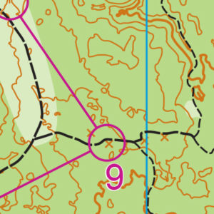
Off-trail choices are allowed in Putney Woods except for areas marked as private property on the map where one must stay on the trails.
Putney Woods has some areas that are “runnable”, but most areas have either heavy undergrowth or have a lot of fallen trees and debris, which often makes the trails the most attractive route choice.
Over the years, the park has developed more rootstocks, depressions, knolls, and stumps. The map has been updated, and more of these features and a few trails have been added.
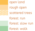
Vegetation as shown on this map can be quite mixed as represented. Some light green is easily passable while others not so much. Use your eyes more than the map to judge vegetation as you move along. Medium green intensifies due to more deadfall and other less friendly brushes (tangling vines, prickly bushes). Dark green should generally be avoided.
Some controls are close together in some areas, so check that the feature and the control code match your course.
A green X on the map is a stump and a brown triangle on the map is a rootstock. These are both represented by an X in a circle on the control descriptions.
Safety bearing is south-west.
SCHEDULE
Tentative schedule (subject to change)
9:00am-11:15pm – Check-in
9:30am-11:30am – Starts (after you’ve registered, sign up for a start time, which is available two weeks before the race; if you don’t pick a start time by the Wednesday before the race at 11:59pm, you’ll have to wait for an available spot on race day)
9:30am-10:30am – Newcomer instruction
2:30pm – Courses close*
*Wear a watch to ensure that you return to the finish by course closure time, even if you have to abandon your course to do so. Those returning after course closure will be disqualified and will make the volunteer staff very grumpy.
Why is there a start window?
This event uses an interval start, which means that participants are started in waves instead of all at once. When you arrive at the start tent, find the chute for your course and follow the start volunteer’s instructions.
PRICES
Online pre-registration only!
$22 base price
– subtract $5 for CascadeOC members
– subtract $5 for using your own e-punch
Participating as a group? Just $5 for each additional adult (18+) group
member, no cost for additional minors. Group max size is 4 including the group leader.
What’s an e-punch?
An e-punch records your race. At each control, you’ll dip the e-punch into an electronic box, which will beep and flash as confirmation. After you finish, you’ll download the e-punch at the download tent and get a receipt that show which controls you visited and how long you took between each; these are your “splits.”
Part of the fun of orienteering is comparing your splits with people who completed the same course, and discussing the routes you took!
SIGN UP
LOCATION
PARKING
Parking is available on site.
CARPOOL
Looking for a carpool? Join the club email group and share your request to find a ride.
THE MAP
The Putney Woods map is all woodsy trails, with widespread underbrush alongside, reminiscent of Bridle Trails. But there are several key differences. First, there are areas of lighter vegetation in light-green areas that are accessible off-trail, offering a wider degree of navigational options, especially for more advanced navigators.
Novice orienteers should be aware that the northern part of the map doe not have a street border; it is directly adjacent to Saratoga Woods park, making it possible to end up off-map with a single turn onto the (one and only) wrong trail. (Note to course-setters: This is a good place for an out-of-bounds sign during the event).
Many trails follow an almost grid-like patterns, making parallel feature errors possible, while others in hilly areas wind almost randomly up and down terrain. There are plenty of areas to practice contour recognition. One area to watch out for is the center-south part of the map; several trails lead into this open, appealing navigational area–but it is private property and should be avoided! (Note to course setters: Another good place for out-of-bounds signs).
Read more on the map pageSAFETY & ETIQUETTE
Return to the Finish
All participants MUST return to the finish and download their e-punch or turn in their punch card.
Even if you have not finished your course, you must still return to the the finish and confirm with event staff that you have returned safely.
Out of Bounds
Some areas may be marked out of bounds. It is imperative to respect these boundaries to maintain our relationships with land managers. Participants MUST NOT go out of bounds. Any participant caught going out of bounds will be disqualified.
Course Closure
All participants MUST return to the finish by course closure time. If a participant does not return by course closure, event volunteers will begin coordinating a search party.
If you need a long time on the course, start as early in the start window as possible, wear a watch, and be prepared to cut your course short to make it back by the course closure time.
Whistle
All participants MUST carry a whistle on the course. Complimentary whistles are available at the start tent (please only take one).
If you are injured on the course and need assistance, blow three long blasts to call for help.
If you hear a call for help, abandon your course to find the person in distress.
Voices
Part of the fun and fairness of orienteering is navigating your own course, so please be polite when you find a checkpoint and don’t holler that you’ve found it.


